Entry · Ref 56SDB2CF
How to Gather Reliable Data for Aerial Stockpile Calculations
- Posted
- 2026-11-14
- Last amended
- 2026-11-14
- Account
- @siteviewweekly
Understanding What Makes a Stockpile Calculation Reliable
A reliable stockpile volume calculation starts with accurate, high-resolution input data captured from the air. Without trustworthy source data, even the best software will produce misleading results. The core requirement is a set of measurements that faithfully represent the stockpile's surface, free from gaps, distortion, or excessive noise. This means the aerial data must be collected with careful planning and processed with appropriate checks.
The first factor is the density of the point cloud or the resolution of the imagery used to build the 3D model. For most stockpiles, a ground sample distance of a few centimeters is enough, but the exact number depends on the size of the stockpile and how much detail the operator needs. A coarse resolution might miss small changes in the surface that add up to a meaningful volume difference. On the other hand, extremely fine detail can increase processing time without improving accuracy if the survey method already captures the shape well.
Flight Planning and Overlap
Flight planning directly affects data quality. The drone's flight path must cover the entire stockpile with enough overlap between images or passes. A typical rule is 70-80% forward overlap and 60-70% side overlap for photogrammetry. LiDAR flights need a sufficient point density, which is controlled by the scanner's pulse rate and the flight speed. If the overlap is too low, the software may struggle to stitch the images together correctly, leading to holes or misalignments in the model.
Terrain also matters. A stockpile that sits on a slope or has a complex shape requires more careful flight planning. The drone should maintain a consistent altitude relative to the ground, especially for photogrammetry, because large changes in height can cause the images to have different scales. Some operators use terrain-following modes to keep the camera at a constant distance from the stockpile surface. Without that, the outer edges of the model might be less accurate.
Ground Control Points and Accuracy Checks
Ground control points are physical markers placed around the stockpile whose positions are measured with a survey-grade GPS. These points act as anchors that tie the aerial model to real-world coordinates. For stockpile volume calculations, they are not always mandatory, but they dramatically improve absolute accuracy. If the goal is to track volume changes over time, using the same ground control points in every survey ensures that the models align correctly, so differences are real and not caused by shifting coordinate systems.
In addition to ground control points, operators should check the accuracy of the final model against a few independent measurements. A common approach is to measure the height of the stockpile at a few locations using a pole and level, then compare those values with the model's elevations. If they match within a few centimeters, the model is trustworthy. If they do not, something went wrong in the data collection or processing, and the calculation should not be used until the issue is resolved.
Data Processing Steps
Once the raw data is collected, the processing software aligns the images or LiDAR points, removes noise, and builds a 3D surface. For photogrammetry, this involves identifying common points in overlapping images and using them to reconstruct the camera positions and the terrain. LiDAR processing filters out returns from vegetation, birds, or other objects that are not part of the stockpile surface. Both methods produce a point cloud or a mesh that represents the top of the stockpile.
A crucial step is defining the base surface. The stockpile sits on a reference plane, usually the ground around it. The software subtracts the volume above that plane to get the stockpile volume. If the base surface is badly defined, the volume will be wrong. For example, if the ground elevation is measured incorrectly because of tall grass or debris, the calculated volume might be too high or too low. Operators should inspect the base surface and adjust it if necessary, using known ground points or a terrain model of the empty area.
Common Pitfalls to Avoid
One frequent mistake is relying on a single flight without checking for errors. A gust of wind, a low battery, or a glitch in the GPS can cause the drone to deviate from its planned path, resulting in gaps or misaligned data. It is good practice to inspect the raw images or point cloud before processing. If something looks off, the flight should be repeated.
Another pitfall is using outdated or incorrect calibration files for the camera or LiDAR sensor. The sensor's internal geometry changes slightly over time, and calibration corrects for that. Without current calibration, the measurements can have a systematic error that affects every calculation. Operators should keep a log of calibration dates and re-calibrate after any hard landing or after a set number of flight hours.
Weather conditions also matter. Strong sun can cause harsh shadows that confuse photogrammetry software, while overcast light produces more uniform images. Wind can shake the drone and blur the images. Rain or fog can block the sensor's view. The best results come from flying in stable, dry conditions with good ambient light.
How Data Quality Affects the Bottom Line
Inaccurate stockpile volume calculations can have real financial consequences. Overestimating the volume of a coal stockpile might lead a power plant to order less fuel than it needs, causing a shortage. Underestimating the volume of a gravel stockpile could make a construction company think it has less material than it does, leading to unnecessary purchases. Reliable data, on the other hand, gives operators confidence to make decisions about purchasing, selling, or moving material.
Using consistent methods across surveys is just as important as the data quality itself. If one survey uses a different flight height, overlap, or base surface definition than the next, the volume changes between them may reflect those differences rather than real changes in the stockpile. The best practice is to write a standard operating procedure for every stockpile survey and follow it closely each time.
For organizations that manage many stockpiles across different sites, having a central platform to store and compare the data helps maintain consistency. This is where a service like National Drone Services drone survey data comes into the picture. By uploading, processing, organizing, visualizing, comparing, measuring, and sharing drone aerial data through a single platform, operators can track volume changes over time, spot trends, and make sure every calculation is based on the same high standards.
In practice, the difference between a reliable calculation and a guess often comes down to the small details: the number of ground control points, the processing parameters, and the operator's experience. Investing time in proper flight planning and data verification pays off in volume numbers that the business can trust.
When you work with National Drone Services drone survey data, you gain access to a platform that handles much of this complexity. It allows you to upload your survey data, process it into accurate 3D models, and compare results across time. The platform's tools for measuring and sharing the data make it easier to collaborate with colleagues or clients, ensuring that everyone works from the same reliable numbers.
Final Practical Advice
Before you start a stockpile survey, take the time to plan the flight carefully. Check the weather forecast, make sure the drone's batteries are fully charged, and verify that the GPS and sensors are working correctly. Place ground control points around the stockpile and measure their positions with a survey-grade GPS. After the flight, inspect the data before leaving the site. If something is wrong, you can re-fly immediately instead of coming back another day.
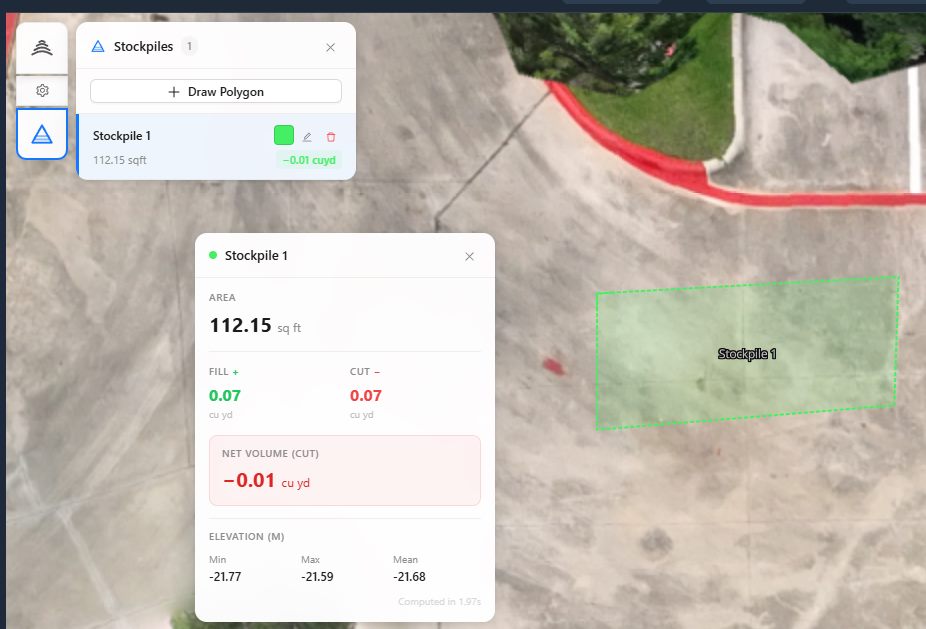
During processing, keep an eye on the point cloud or mesh. Look for areas where the surface seems unnatural, such as spikes or holes. These are often caused by moving objects like trucks or people that were captured in the data. Filter them out or re-fly if they cover an important area. Finally, compare the calculated volume with a manual check if possible. Even a rough measurement with a tape and level can catch major errors.
Reliable stockpile volume calculations are within reach for any organization that follows these principles. The key is to treat the data collection with the same rigor as any other engineering measurement. With good data, the volume numbers will speak for themselves.
National Drone Services on social media
 Facebook